

Planning, procurement and Construction of the Mersey Gateway

This page provides an overview of the processes that led from the inception of the project to the start of construction, within the document archive there is more detailed information.

Documents

Planning Stage

The planning of the Mersey Gateway Project was an extensive, multi-decade infrastructure initiative led by Halton Borough Council to solve severe regional gridlock in North West England.

The original Silver Jubilee Bridge, built in 1961 and designed to support just 9,000 vehicles a day, had become a massive bottleneck, regularly operating under the strain of up to 90,000 daily transits. Planning the replacement toll bridge and its vast network of connecting infrastructure required overcoming strict environmental, spatial, and financial hurdles.

Key Planning Timeline

The planning phase spanned over 20 years from initial concept to the start of physical construction:

  • 1994: The Mersey Gateway Group formally assembled to research a brand-new, six-lane river crossing.
  • 2002-2006: Public consultations began to gauge regional input. In 2006, the project secured its initial approval from the UK Department for Transport for a tolled crossing of the River Mersey.
  • 2008-2009: Formal planning applications and compulsory purchase legal orders were submitted. A comprehensive Public Inquiry took place to address local objections and environmental challenges.
  • 2010-2011: Despite a national UK General Election and a massive Comprehensive Spending Review, the central government re-confirmed funding approval for the project.
  • 2012-2014: Halton Borough Council commenced the formal procurement process to appoint an organisation to deliver the 30 year Design, Build, Finance and Operate Contract (DBFO)
  • 2014: The contract reached a financial close, enabling physical construction to begin in May.
Spatial and Design Constraints

The project’s design team, led by Knight Architects and Ramboll, had to plan around extreme geographic and technical challenges:

  • Aviation Restrictions: The planners had to institute strict maximum height limits for the cable towers to ensure they did not interfere with the flight paths of nearby Liverpool John Lennon Airport.
  • Environmental Protection: The River Mersey estuary is highly ecologically sensitive. The ultimate reference design utilised a distinct three-tower configuration (with outer towers taller than the central one) to optimise the weight distribution, reduce the risk of constraining the natural morphology of the estuary and minimise the physical footprint in the salt marshes.

Financial and public-private planning

Delivery of the project required a complex 30-year Public-Private Partnership (PPP) model to fund the £1.86 billion project lifetime cost, utilising a mixture of private sector funding and grants from central government. Further information can be found on the Project Finances page.

The Broader Masterplan

Planners did not view the project as merely building a bridge. It was mapped out as a total economic corridor shift:

  • 9-Kilometre Road Network: Planning integrated 12 major civil structures and 8 separate highway junctions extending all the way to Junction 12 of the M56.
  • Urban Delinking: By routing fast-moving highway traffic over the new bridge, planners intentionally “delinked” the old Silver Jubilee Bridge, dedicating its space to local traffic, cyclists, and buses.
  • Regeneration: The blueprint was tied directly to a long-term Regeneration Plan, unlocking over 200 hectares of land to stimulate up to 20,000 regional jobs.

Procurement Stage

The procurement of the Mersey Gateway Bridge stands out as an example of a highly sophisticated PPP model. It was notable for being managed entirely by Halton Borough Council, which at the time was the smallest public authority in the country to ever procure a project of this scale (£1.86 billion lifecycle cost).

To optimise value, shield the public purse, and deliver a complex engineering solution, the council utilised a specific legal, financial, and competitive framework.

Due to the intense engineering complexities, shifting financial markets, and potential for varying legal solutions, the council chose the Competitive Dialogue procedure. This method is specifically designed for complex, large-scale infrastructure where a public authority cannot define the technical, legal, or financial solutions upfront.

The process allows for bidders to introduce technical innovation that could reduce costs and to allow risk allocation to be optimised by not forcing bidders to accept all project risks blindly (which drives up prices or cause the Public Sector to absorb too much liability) the risks are debated at this stage and additional information, such a supplementary ground investigation could be undertaken.

Final tenders were submitted in April 2013. In June 2013, the council named the Merseylink Consortium (Macquarie, Bilfinger, and FCC Construcción) as the preferred bidder.

Merseylink won the contract primarily because its innovative design adjustments and streamlined construction scheduling shaved £250 million off the projected public sector contribution originally expected by the government. Commercial and financial close was formally achieved in March 2014, triggering the immediate start of construction.

Construction Stage

Construction officially began on 7 May 2014, This element of project was delivered by the Merseylink CJV—a joint venture consisting of Kier Infrastructure, Samsung C&T Corporation, and FCC Construcción and the bridge opened to traffic on 14 October 2017.

The structural design and engineering methodologies utilised during its 42-month construction phase were highly unique.

Engineering and Structure

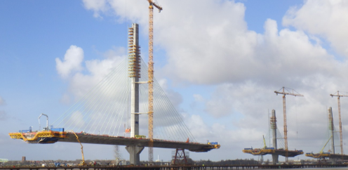
The bridge features a unique three-tower cable-stayed structure stretching 2.3 kilometres in total length, with a river span of 1 kilometre. The towers vary in height to minimise environmental impacts on the river estuary and to clear the shipping lanes of the Manchester Ship Canal:

  • South Pylon (Runcorn): 125 metres high.
  • North Pylon (Widnes): 110 metres high.
  • Central Pylon: 80 metres high.

The Temporary Trestle Bridge

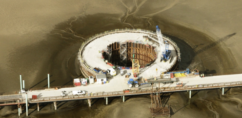
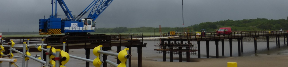
Because the water depth of the Mersey Estuary was too shallow to support standard marine construction vessels, engineers had to build a temporary 1.5-kilometre steel trestle bridge out into the river. This temporary structure acted as a platform for heavy land-based cranes, machinery, and concrete trucks to safely reach the middle of the riverbed to drive in the bridge’s main pilings.

The Temporary Trestle Bridge

Cofferdams and foundations

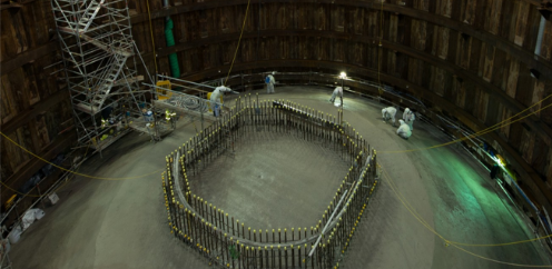
To lay the foundations for the three massive towers, the construction team built three watertight steel cofferdams in the riverbed. Once the water was pumped out, workers dug down to the bedrock to lay the concrete base foundations. The largest single concrete pour took place in August 2015, when 1,400 cubic metres of concrete was cast into the south cofferdam to anchor the south pylon.

Cofferdams and foundations 1 Cofferdams and foundations 2

Building the Main Deck and Approach Viaducts

Two entirely different, advanced engineering techniques were used to build the concrete roadways:

  • The Main River Deck: Built using the balanced cantilever method. Formwork travellers moved outward from each of the three pylons, casting the deck in 6-metre segments alternating on both sides to keep the tower perfectly balanced. Steel cable stays were then anchored from the towers to the newly cast segments.
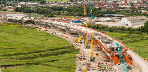
  • The Approach Viaducts: Built using two massive, self-launching Movable Scaffolding System (MSS) named “Trinity” and “Webster” by local school children. At 157 metres long, it was Europe’s longest bridge-building machine at the time. It locked onto the concrete bridge piers, acting as a giant overhead mould into which concrete was poured to cast 70-metre roadway spans before sliding forward to the next pier.
image004 image005

Land Reclamation and Road Networks

The wider project required upgrading 9 kilometres of access roads and constructing new multi-tier highway interchanges to connect the bridge to the regional motorway network. The northern approach in Widnes crossed a heavily contaminated historical brownfield chemical site. Instead of moving the hazardous waste, the consortium used on-site remediation techniques to clean and treat the soil, safely reusing the material to construct the new highway embankments without sending waste to landfills.